Heads Up: Possible Severe Weather Invades Central, West Alabama on Tuesday
We have been closely monitoring for the last several days a system that has the potential to bring severe weather to the southern region starting today in portions of Texas, Western Louisiana, and Southwest Arkansas. Then Tuesday, this same system will impact Louisiana, Mississippi, Alabama, and the Florida panhandle. Then it will move into Georgia, South & North Carolina, and Southern Virginia on Wednesday.

The National Weather Service in Birmingham said that this strong weather system will “come in the form of strong thunderstorms along and ahead of a cold front, some of which could be severe. This situation will also result in a risk of localized flash flooding and gusty non-thunderstorm winds throughout the day.”
A big concern for our area is the potential for these strong storms to produce activity during the evening hours. Tomorrow, be sure you do not silence your phones when you get home or when you go to bed. It will be important for you to be able to hear any alerts concerning watches and warnings.
James Spann, ABC 33/40, and Townsquare Media Tuscaloosa Chief Meteorologist said that the “strong to severe storms will likely push into West Alabama tomorrow afternoon, then moving eastward tomorrow night.”
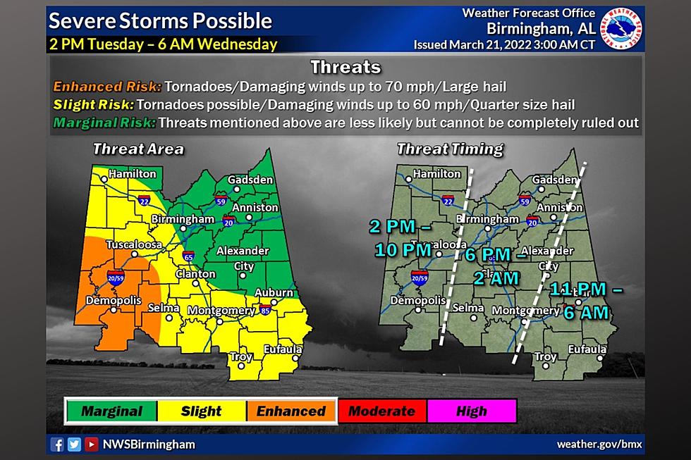
National Weather Service in Birmingham Highlights
Where:
All of Central Alabama.
When:
2 PM Tuesday through 6 AM Wednesday.
Threats:
Tornadoes.
Damaging winds up to 70 mph.
Large hail.
Localized flash flooding.
Non-thunderstorm wind gusts of 35 to 40 mph.
Timing Outlook
Spann said that “storms could enter West Alabama as early as 2:00 p.m. tomorrow; the risk begins for the I-65 corridor (places like Birmingham) around 6:00 p.m., and then over the eastern third of the state after 11:00 p.m.”
Please don’t get caught up in the risk level areas because all modes of severe weather could take place. The counties that our Townsquare Media Tuscaloosa Radio Stations cover are split between the “Enhanced Risk” and “Slight Risk” areas.
Concerns About the Winds
Spann noted that “gradient winds (not related to thunderstorms) could gust as high as 35/40 mph across the state tomorrow afternoon and tomorrow night. A wind advisory will be needed tomorrow.”

Influx of Rain
“Rain amounts of 2-3" are likely over the western half of the state, with 1-2" for the eastern counties. A flash flood watch will likely be required for parts of West Alabama,” said Spann.

Non-Stop Coverage During a Tornado Warning
At any time any of our coverage area counties are under a Tornado Warning, we will have nonstop severe weather coverage for you on the following radio stations:
Praise 93.3
92.9 WTUG
95.3 The Bear
METV 97.5
Catfish 100.1
Tide 100.9
ALT 101.7
105.1 The Block
It would be a great idea to refresh yourself with the Alabama State map, so you can be aware of your county and the counties around you (including Mississippi).
Townsquare Media Coverage Area Counties
Bibb
Fayette
Greene
Hale
Jefferson
Lamar
Perry
Pickens
Sumter
Tuscaloosa
Walker
(Source) Click here to follow the Facebook Page for James Spann. For more from the National Weather Service Birmingham, click here.
New Tuscaloosa Restaurants & Retail in 2021
Tuscaloosa Restaurants and Stores That Closed for Good in 2021
LOOK: Food history from the year you were born
50 Most Popular Chain Restaurants in America
More From Tuscaloosa Thread


