Tropical Depression 19 Could Impact Alabama Coast
Tropical Depression 19 Could Impact Alabama Coast
[Update Saturday, September 12, 2020, at 12:15 pm]
Headlines for Tropical Depression 19
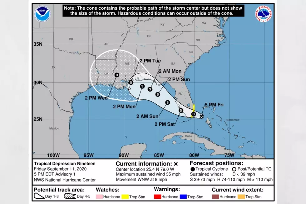
Today, TD 19 continues to move westward into the Gulf.
Conditions indicate the TD 19 could develop into a Tropical Storm later today. There is also the possibility of the system developing into a Hurricane before landfall on Tuesday.
Tropical Storm Watch is in place for the Ochlockonee River to Okaloosa/Walton County Line. This means circumstances are favorable for tropical storm conditions within in the next 48 hours.
Impacts on our listening areas are yet to be determined at this time. There will be more information to develop as the system gains strength.
[Update Friday, September 11, 2020, at 6 pm]
Tropical Depression 19 has the potential to develop into a tropical storm soon. The timeline for this tropical depression could shift because of the intensification that could take place over the Gulf of Mexico. Right now, the thought is that tropical force winds could reach the Northwest Florida coast by Monday morning. Then early Tuesday morning it could reach the Mobile Bay with the timing reaching the Louisiana and Mississippi border on Tuesday afternoon.
[Update Friday, September 11, 2020, at 5:10 pm]
Hurricane season is still in full swing as it doesn’t end until November 30, 2020. We are currently monitoring Tropical Depression 19. This weekend is very favorable for further development of the system, which could bring lots of rain to the Gulf Coast and increases our rain levels in our listening areas.
The National Weather Service Birmingham provided an update on their Facebook page to note that they are “monitoring a disturbance near Miami which is showing signs of organization. This feature will move into the Gulf of Mexico over the weekend and may strengthen into a Tropical Depression. For us, this could result in higher rain chances early next week.”
According to the National Hurricane Center, “the system is forecast to strengthen to near hurricane intensity by early next week as it moves across the northeastern Gulf of Mexico. Dangerous impacts from storm surge, wind, and heavy rainfall will be possible along the Gulf Coast from the Florida Panhandle to southeastern Louisiana this weekend and early next week.”
(Source) For more from the Facebook page of the National Weather Service Birmingham, click here. For more from the National Hurricane Center, click here.

KEEP READING: Get answers to 51 of the most frequently asked weather questions...
More From Tuscaloosa Thread


