Triple Digit Heat Index Values Expected in Portions of Alabama
Weather Alerts
The National Weather Service in Birmingham has issued a "Heat Advisory" across West Alabama for the next few days. The advisory runs from today at 11:00 a.m. until Thursday at 9:00 p.m.

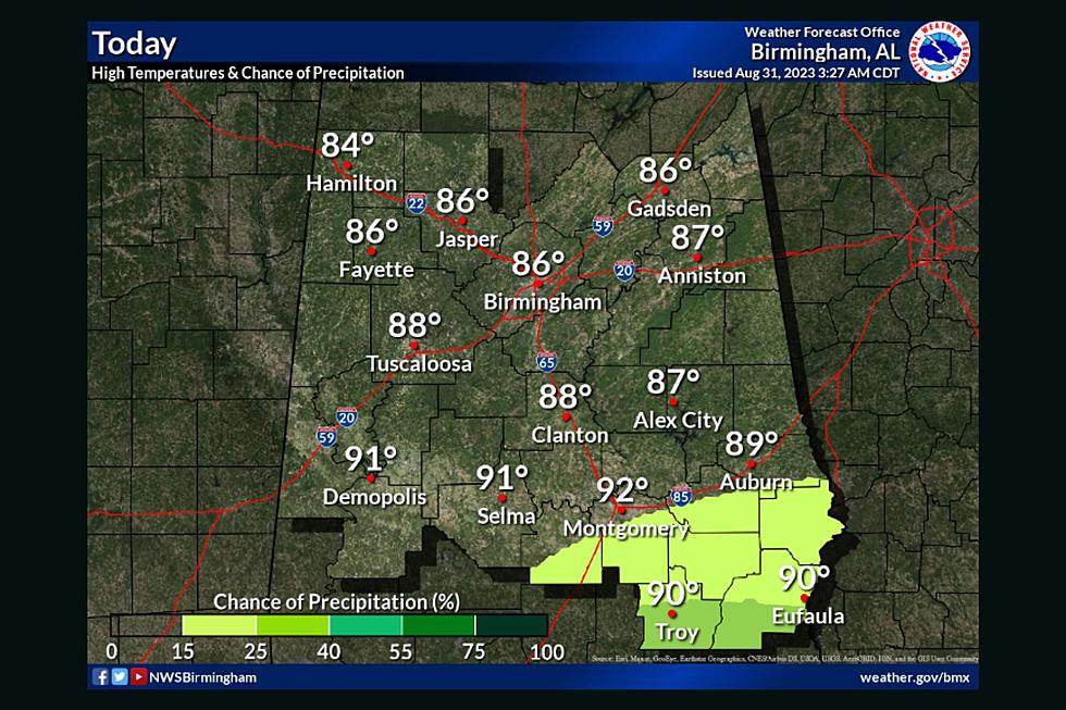
Heat indices for today will be between 105-108 degrees.
The "Heat Advisory" impacts the following counties: Autauga, Barbour, Bibb, Blount, Bullock, Chambers, Chilton, Coosa, Dallas, Elmore, Fayette, Greene, Hale, Jefferson, Lamar, Lee, Lowndes, Macon, Marengo, Marion, Montgomery, Perry, Pickens, Pike, Russell, Shelby, St. Clair, Sumter, Talladega, Tallapoosa, Tuscaloosa, Walker, and Winston.
This triple-digit heat wave is expected to run through Friday.
What Areas Will Experience Severe Weather?
James Spann, ABC 33/40, and Townsquare Media Tuscaloosa Chief Meteorologist said that “before sunrise, we have an organized mass of storms over Tennessee, and these will likely move into North Alabama by mid-morning.”
The threats for the North Alabama area include damaging winds up to 60 mph and quarter-sized hail as it is under a “marginal risk.” Spann said that “the storms are expected to fade and dissipate by afternoon, and a decent part of the state will be dry with a partly sunny sky.”
(Source) Click here to follow the Facebook Page of James Spann. Click here for more information from the National Weather Service in Birmingham.
Hot Weather Safety Tips
Heat-Related Weather Terminology
More From Tuscaloosa Thread