Possible Severe Weather Kicks Off the New Year in Central Alabama
As we welcome a New Year, we are also preparing for another round of severe weather. There have been adjustments made to the outlook for the probable severe weather event for today, Saturday, January 1, 2022.
There will be a cold front that will move through our coverage areas later today/tonight and into Sunday morning. Ahead of and along this cold front, there will be the potential for showers and thunderstorms in which some could become strong to severe.
The National Weather Service in Birmingham advises the following for all of Central Alabama:
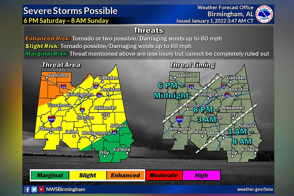
Threats
A couple of tornadoes
Damaging winds up to 60 mph
Locally heavy rainfall may result in flooding of low-lying or poor drainage areas
Non-thunderstorm wind gusts up to 40 mph
Timeline
6 pm this evening through 8 am Sunday
What to do Before the Storm
As you prepare for this incoming storm be sure that you have multiple ways to receive weather information, be aware of the county you live in, know your place on the map (so you can know what could be approaching your area), and determine your safe place ahead of the weather event.

James Spann, ABC 33/40, and Townsquare Media Tuscaloosa Chief Meteorologist further explains the biggest question that involves “the potential development of discrete supercells ahead of the line this afternoon and evening. There is a well defined warm layer about 10,000 feet off the ground this morning, a "cap". If this doesn't erode, then things could remain quiet through the afternoon hours across Alabama with little development.” Spann further expresses that “if the cap breaks, scattered storms that form ahead of the line could produce tornadoes... maybe even a few strong tornadoes.”
Spann shared that “there is an "enhanced risk" (level 3/5) of severe thunderstorms later today and tonight north of a line from Millport to Warrior to Gadsden. A "slight risk" (level 2/5) extends down to Grove Hill, Fort Deposit, and Auburn, and a "marginal risk" (level 1/5) covers the rest of South Alabama (except for Dothan, where no severe storms are expected).”
Core Timing
Spann noted that “if the cap breaks, storms could begin to form over Northwest and North Alabama as early as 4:00 this afternoon. The core window for the northern half of the state comes from about 6:00 p.m. until 3:00 a.m. Storms will remain possible over South Alabama through tomorrow morning around 9:00 a.m.... but the threat is lower there.”
During severe weather scenarios, Townsquare Media radio stations will bring you updates for all types of severe weather. Also, we will host wall-to-wall cover during a Tornado Warning to give you the information you need to keep safe and informed.
Townsquare Media Radio Stations
Praise 93.3, 92.9 WTUG, 95.3 The Bear, Nick 97.5, Catfish 100.1, Tide, 100.9, ALT 101.7, and 105.1 The Block.
Townsquare Media Coverage Areas
Bibb
Fayette
Greene
Hale
Lamar
Perry
Pickens
Sumter
Tuscaloosa
Walker
(Source) Click here to follow the Facebook Page for James Spann. For more from the National Weather Service Birmingham, click here.
Most Shocking Crime Stories of 2021
2021 in Review: Top Stories from The Tuscaloosa Thread
All Homicides in Tuscaloosa County in 2021
More From Tuscaloosa Thread