Real-time Updates for Severe Weather in West Alabama Tuesday, November 25th
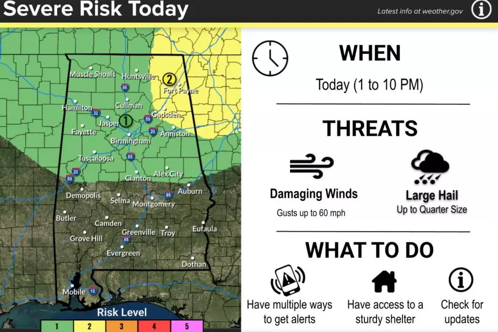
A band of severe storms is expected to impact West Alabama early Tuesday morning, predominantly in the predawn hours.
As the National Weather Service in Birmingham hones in on threats, we'll provide real-time weather updates that affect our readership and listening area.
Look out for here for ongoing updates about watches and warnings as they are issued - we'll send any severe thunderstorm or tornado warnings in our coverage area to our mobile app audience, too.
The primary threats are torrential rain and straight-line winds, with the low chance of tornadic activity.

NWS ISSUES SPECIAL WEATHER STATEMENT FOR 3 WEST ALABAMA COUNTIES
...A STRONG THUNDERSTORM WILL IMPACT SOUTHWESTERN TUSCALOOSA...
SOUTHEASTERN PICKENS AND NORTHEASTERN GREENE COUNTIES THROUGH 815 AM
CST...

At 724 AM CST, Doppler radar was tracking a strong thunderstorm near
Mantua, or 10 miles southeast of Aliceville, moving east at 30 mph.

HAZARD...Wind gusts up to 40 mph and pea size hail.

SOURCE...Radar indicated.

IMPACT...Gusty winds could knock down tree limbs and blow around
         unsecured objects. Minor hail damage to vegetation is
         possible.

Locations impacted include...
Northport, Moundville, Coker, Union, Mantua, Jena, Knoxville,
Benevola, Lake Lurleen State Park, Snoddy, Ralph, Buhl, Flatwoods,
Fosters Boat Landing, Mound State Park, Fosters, Kirk, Pioneer,
Romulus, and Elrod.

PRECAUTIONARY/PREPAREDNESS ACTIONS...

If outdoors, consider seeking shelter inside a building.

&&

LAT...LON 3327 8802 3335 8764 3301 8760 3300 8763
      3301 8764 3301 8771 3299 8771 3299 8773
      3298 8773 3292 8801
TIME...MOT...LOC 1324Z 257DEG 28KT 3303 8802

MAX HAIL SIZE...0.25 IN
NWS ISSUES SEVERE THUNDERSTORM WARNING FOR FOUR WEST ALABAMA COUNTIES
The National Weather Service in Birmingham has issued a * Severe Thunderstorm Warning for... Walker County in central Alabama... Northern Tuscaloosa County in west central Alabama... Winston County in northwestern Alabama... Eastern Fayette County in west central Alabama... * Until 445 AM CST. * At 357 AM CST, severe thunderstorms were located along a line extending from near Winston Free State Barn to near Oakman to near Samantha to 6 miles southeast of Gordo, moving east at 50 mph. HAZARD...60 mph wind gusts. SOURCE...Radar indicated. IMPACT...Expect damage to roofs, siding, and trees. * Locations impacted include... Northern Tuscaloosa, Northport, Jasper, Sumiton, Cordova, Dora, Carbon Hill, Lynn, Arley, Berry, Double Springs, Parrish, Coker, Oakman, Addison, Sipsey, West Jefferson, Kansas, Nauvoo, and Camp McDowell. PRECAUTIONARY/PREPAREDNESS ACTIONS... For your protection move to an interior room on the lowest floor of a building.&&
NWS ISSUES SPECIAL WEATHER STATEMENT FOR SIX WEST ALABAMA COUNTIES
...STRONG THUNDERSTORMS WILL IMPACT WALKER...TUSCALOOSA...
SOUTHEASTERN MARION...EASTERN PICKENS...WINSTON AND FAYETTE COUNTIES
THROUGH 445 AM CST...

At 341 AM CST, Doppler radar was tracking strong thunderstorms along
a line extending from Lake Buttahatchee to 9 miles east of Ashcraft
Corner to near Aliceville. Movement was east at 50 mph.

HAZARD...Wind gusts up to 40 mph.

SOURCE...Radar indicated.

IMPACT...Gusty winds could knock down tree limbs and blow around
         unsecured objects.

Locations impacted include...
Tuscaloosa, Northport, Jasper, Winfield, Fayette, Sumiton,
Aliceville, Cordova, Dora, Carbon Hill, Gordo, Reform, Carrollton,
Lynn, Arley, Holt, Lake View, Brookwood, Berry, and Double Springs.

PRECAUTIONARY/PREPAREDNESS ACTIONS...

If outdoors, consider seeking shelter inside a building.

Torrential rainfall is also occurring with these storms and may lead
to localized flooding. Do not drive your vehicle through flooded
roadways.
For ongoing coverage of the threat until it passes, stay connected to the Tuscaloosa Thread.
Top Stories from the Tuscaloosa Thread (11/17 - 11/24)
Gallery Credit: (Stephen Dethrage | Tuscaloosa Thread)
More From Tuscaloosa Thread