Alabamians Should Prepare for Storms, Influx of Rain, Winds
For the past several days, the Townsquare Media weather center has been closely monitoring a weather system that has the potential to usher in rain, winds, and strong to severe weather in our area and statewide.

James Spann, ABC 33/40, and Townsquare Media Tuscaloosa Chief Meteorologist, has recommended that Alabamians stay "weather aware over the next 30 hours.”
“As the system approaches, winds will increase across the area beginning late Monday afternoon before thunderstorms are expected to begin,” said the National Weather Service in Birmingham.
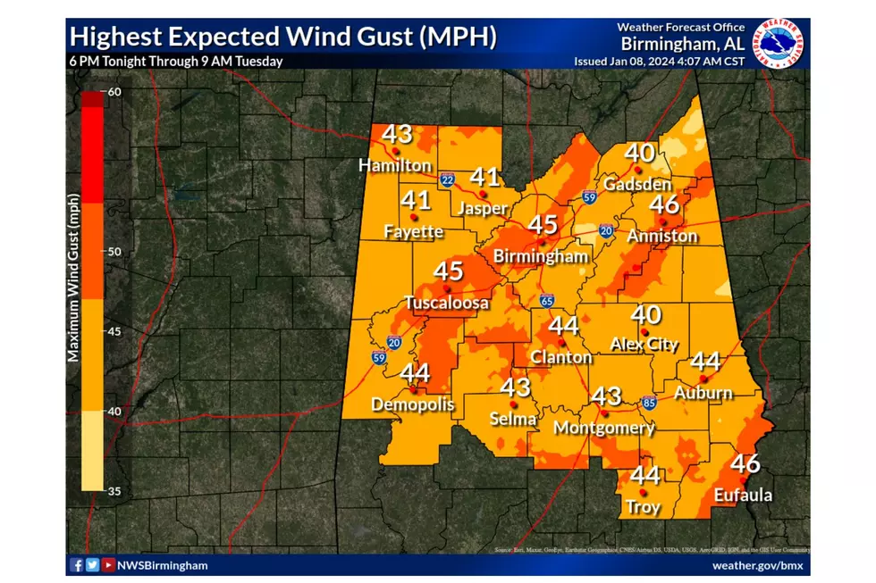
In certain areas, the gradient winds have the potential to reach speeds of up to 50 mph. These strong winds may result in fallen trees and possible power disruptions. A wind advisory was issued yesterday before the storm system to prepare you for this potential impact.
Risk Areas and Timing
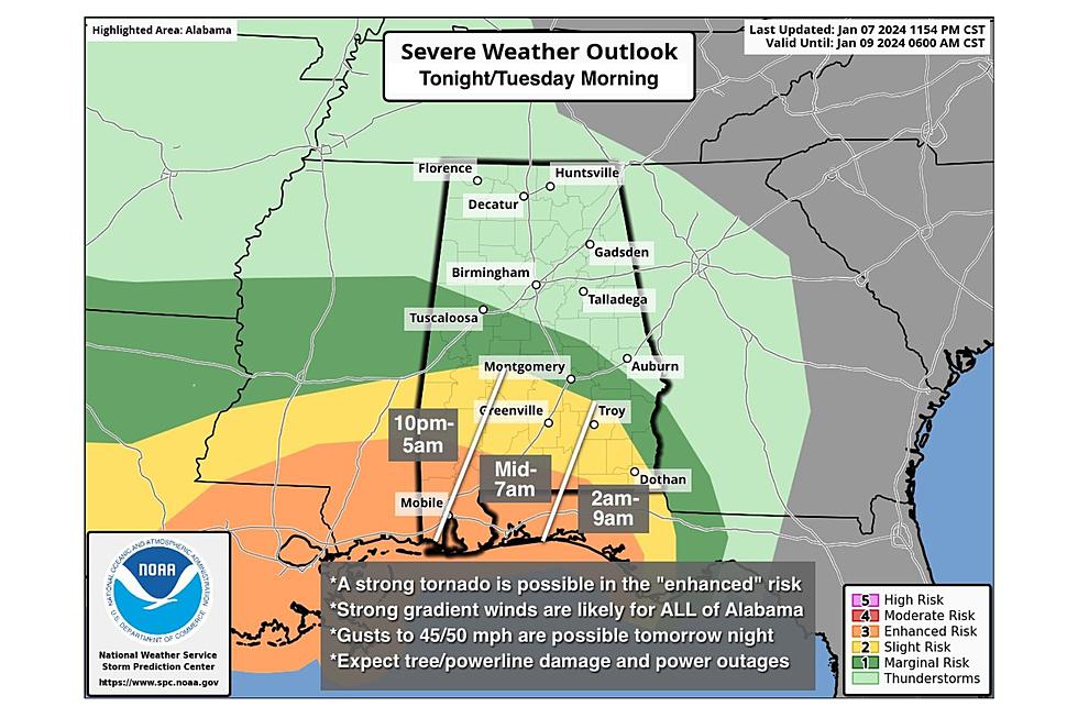
The National Weather Service in Birmingham said the risk area includes the “Southern half of Central Alabama.”
Currently, the impacts for our area should be around 2 a.m. until 7 a.m. with a “marginal risk” of damaging winds up to 60 mph for portions of our coverage area and a few counties with a small portion under a “slight risk” of damaging winds up to 60 mph and a brief tornado possible.
Bibb – a good portion under “marginal risk.”
Greene – entire county under “marginal risk.”
Hale – entire county under “marginal risk.”
Perry – a good portion under “marginal risk” and a small portion under “slight risk.”
Pickens – a small portion under “marginal risk.”
Sumter – a good portion under “marginal risk” and a small portion under “slight risk.”
Tuscaloosa – a small portion under “marginal risk.”
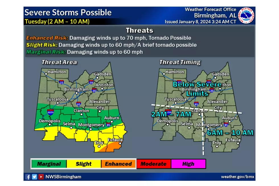
The main threat of severe thunderstorms is in South Alabama's "enhanced risk" (level 3/5) area late tonight into tomorrow morning, said Spann. “A strong tornado (EF-2 or higher) is initially possible across Mobile, Baldwin, Washington, Escambia, and Covington counties and then eastward into Coffee, Geneva, Houston, Henry, and Barbour counties in the 4:00 to 9:00 a.m. time frame tomorrow.”

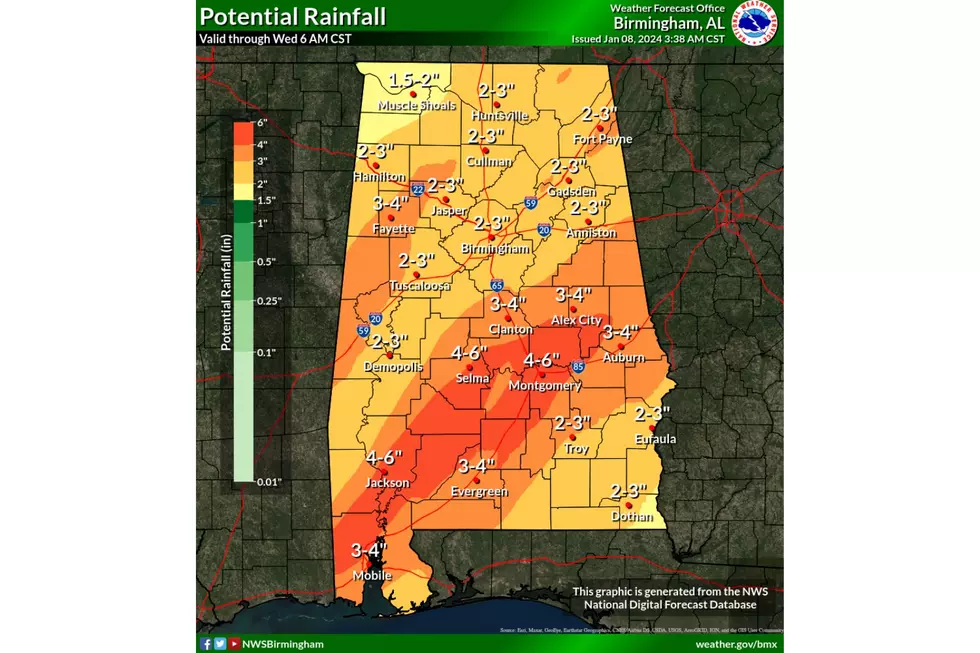
Influx of Rain
You can expect about 2 to 3 inches of rain through Tuesday, raising concerns about the potential for flooding.
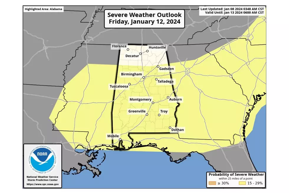
More Severe Weather? Winter Weather?
There is the possibility of more severe weather later this week. We will continue to monitor the potential impact on our Townsquare Media coverage area for Friday.
Also, this weekend, the temperatures will be much colder. However, it’s possible that some of the "coldest air so far this season will roll into Alabama by the middle of next week, dropping lows into the teens over the northern half of the state,” said Spann.
Plus, the “weather system has the potential to bring cold rain and maybe some wintry precipitation into Alabama Monday night or Tuesday. WAY too early to be specific, of course,” said Spann.
LOOK: 20 of the biggest insects in the world
Gallery Credit: Andrea Vale
Quiz: Do you know your state insect?
Gallery Credit: Andrew Vale
States with the most registered hunters
Gallery Credit: Meagan Drillinger
LOOK: Here are the pets banned in each state
Gallery Credit: Elena Kadvany
More From Tuscaloosa Thread