
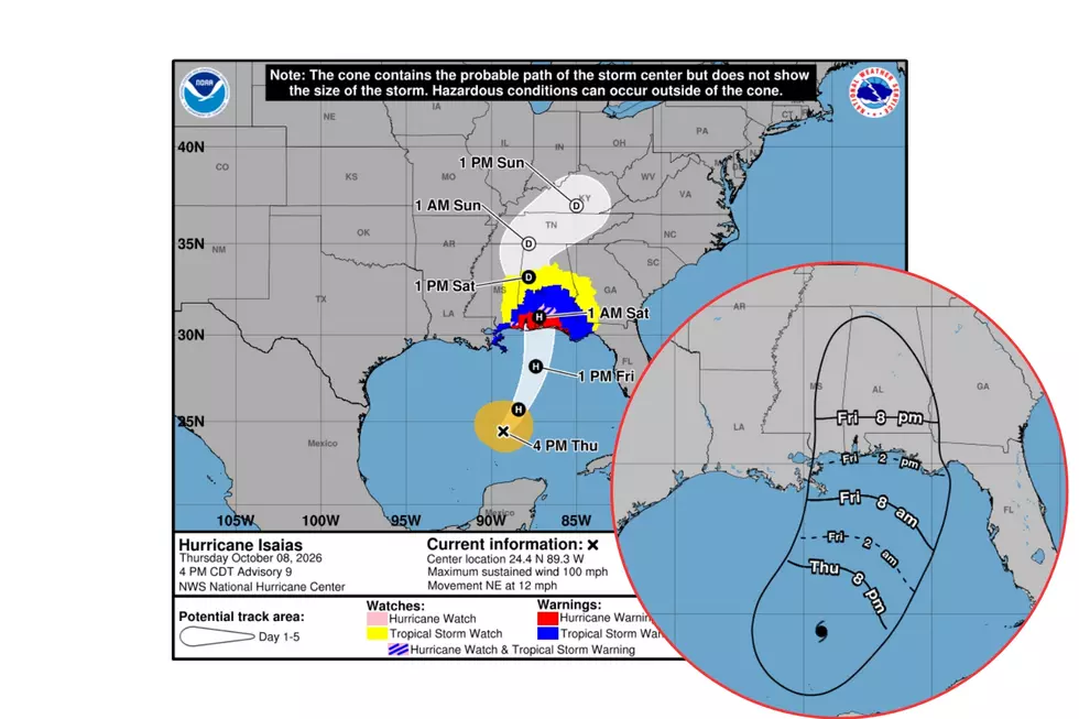
Hurricane Isaias Strengthens to Category 2 as Alabama Prepares
Alabamians across the state are gearing up for Hurricane Isaias, which has now strengthened to Category 2.
Updated Isaias Stats
- Maximum sustained winds at 100 mph
- Moving Northeast
- Movement speed is at 12 mph
Let’s Chat about Landfall
The Weather Channel reports that Isaias's “forecast track has been nudged slightly eastward.”
All signs point to Isaias strengthening tonight in the central Gulf and taking a more northward approach.
Landfall is currently forecast near Pensacola Beach, Florida, roughly under 250 miles from Downtown Tuscaloosa.
Current West Alabama Weather Alerts Ahead of Isaias Arrival
Bibb
Tropical Storm Watch
Flood Watch from Friday, October 9 at 7 p.m. until Sunday, October 11 at 7 a.m.
Fayette
High Wind Watch from Saturday, October 10 at 1 a.m. until Sunday, October 11 at 1 a.m.
Flood Watch from Friday, October 9 at 7 p.m. until Sunday, October 11 at 7 a.m.
Greene
Tropical Storm Watch
Flood Watch from Friday, October 9 at 7 p.m. until Sunday, October 11 at 7 a.m.
Hale
Tropical Storm Watch
Flood Watch from Friday, October 9 at 7 p.m. until Sunday, October 11 at 7 a.m.
Lamar
High Wind Watch from Saturday, October 10 at 1 a.m. until Sunday, October 11 at 1 a.m.
Flood Watch from Friday, October 9 at 7 p.m. until Sunday, October 11 at 7 a.m.
Perry
Tropical Storm Watch
Flood Watch from Friday, October 9 at 7 p.m. until Sunday, October 11 at 7 a.m.
Pickens
Tropical Storm Watch
Flood Watch from Friday, October 9 at 7 p.m. until Sunday, October 11 at 7 a.m.
Sumter
Tropical Storm Watch
Flood Watch from Friday, October 9 at 7 p.m. until Sunday, October 11 at 7 a.m.
Tuscaloosa
Tropical Storm Watch
Flood Watch from Friday, October 9 at 7 p.m. until Sunday, October 11 at 7 a.m.
Walker
High Wind Watch from Saturday, October 10 at 1 a.m. until Sunday, October 11 at 1 a.m.
Flood Watch from Friday, October 9 at 7 p.m. until Sunday, October 11 at 7 a.m.
West Alabama Potential Impacts
- Windy conditions
- Heavy Rainfall
- Possible Flash Flooding
- Monitoring the possibility of tornadoes near and east of the center track; some West Alabama counties are currently under marginal risk.

Tornado Outlook
James Spann, Alabama Weather Network Chief Meteorologist, said, “Isolated tornadoes are possible along and east of the track. The risk Friday night is from Baldwin and Escambia counties east to Dothan in Alabama, and the western Florida Panhandle. On Saturday, a few tornadoes are possible over the eastern third of Alabama. The tornado threat over the western half of the state is very low.”
What the Townsquare Media Weather Center is Monitoring
We are focused on Isaias's speed and track once the system makes landfall. The big question for West Alabama counties is whether they fall on the track to the east or west, which matters because of the risk of spin-up tornadoes associated to the east of the center.
- More details to come about Hurricane Isaias and what it could mean for West Alabama.
- Since this is an overnight issue, please be sure to keep your phone alerts on when you go to bed Friday night so you can receive important weather alerts.
Mary K. – Weather Forecaster
National Hurricane Center Key Messages
- A life-threatening storm surge is expected from the Mouth of the Mississippi River to Suwannee, Florida. Residents in the warning area should follow advice given by local officials and evacuate immediately if told to do so.
- Damaging hurricane-force winds are expected over portions of the Florida Panhandle, southern Alabama, and southern Mississippi where a Hurricane Warning is in effect. Residents in these areas should prepare for the possibility of long-duration power outages.
- Damaging wind gusts are possible over much of central and northern Alabama, extreme eastern Mississippi, and portions of western and northern Georgia, especially in areas of higher terrain. Additional Tropical Storm and High Wind Watches and Warnings may be required for portions of that area later tonight. Residents should secure loose outdoor items, avoid driving high-profile vehicles, and prepare for power outages.
- Isaias will bring areas of heavy rainfall to the central U.S. Gulf coast and much of the Southeast Friday into the weekend. Considerable flash and urban flooding, along with significant river flooding, will be possible.
Alabama’s Peak Fall 2026 Foliage Color Guide
Gallery Credit: Mary K
LOOK: The top small towns for taking in America's fall foliage
Gallery Credit: Stacker
More From Tuscaloosa Thread