Here’s What You Need to Know About Ida in Tuscaloosa, Alabama
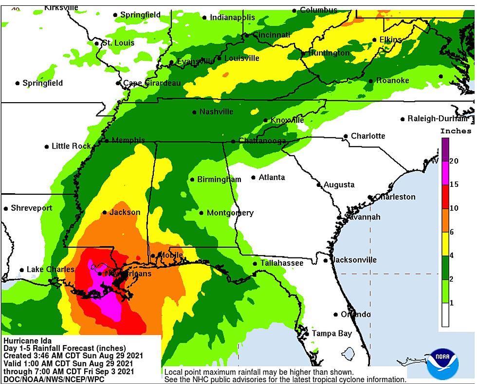
Ida has developed into a very dangerous hurricane as it draws closer to the southeastern coast of Louisiana. Also, Ida is still intensifying. The National Hurricane Center notes that it is an “extremely dangerous category 4 hurricane.”
NOAA aircraft reconnaissance has found Ida to be much stronger. Information indicates that “maximum sustained winds have increased to near 150 mph (240 km/h) with higher gusts. The latest minimum central pressure estimated from reconnaissance aircraft data is 935 mb (27.61 in).”

We are currently monitoring Hurricane Ida for inland impacts and how this will impact Central and West Alabama. James Spann, ABC 33/40, and Townsquare Media Tuscaloosa Chief Meteorologist have provided great insight for our region.
Flooding Risk
“As Ida moves inland, significant flooding impacts are possible across portions of the Lower Mississippi, Tennessee, and Ohio Valleys through Wednesday.”
“Heaviest rain in Alabama will come over the western half of the state, where amounts of 3-6 inches are likely along with the threat of flooding. A flash flood watch is in effect for areas west of a line from Huntsville to Birmingham to Brewton. Rain amounts over East Alabama will be in the 1-3 inch range.” Click here for more information about the Flash Flood Watch.
Wind Risk
“Winds could gust to 40/45 mph across West and North Alabama tomorrow night into Tuesday morning.”
Tornado Risk
“A few isolated tornadoes are possible across West and South Alabama tonight, and statewide tomorrow. Generally speaking, tornadoes associated with tropical systems are short-lived, low topped, and sometimes can touch down with little or no warning.”
Here is the timeline for the potential for tornadoes
Timeline for Potential Tornadoes - 4 am Monday until 4 pm Tuesday
Our news and weather teams at Townsquare Media are closely monitoring Hurricane Ida. We will provide the necessary information and host any essential live coverage on our Townsquare Media radio stations which are 92.9 WTUG, Praise 93.3, 95.3 The Bear, Nick 97.5, Catfish 100.1, Tide 100.9, ALT 101.7, and 105.1 The Block.
(Source) Click here to follow the Facebook Page for James Spann. For more from the National Weather Service Birmingham, click here. Click here for information from the National Hurricane Center.
Townsquare Media Tuscaloosa's Operation Storm Watch is brought to you by Safe-T Shelter. Visit their website here to see their selection of residential and commercial safe rooms and storm shelters. To contact a Safe-T Shelter representative, click here to visit their Facebook page.
Check out the latest radar models here:
If a tornado warning is issued in our area, Townsquare Media Tuscaloosa Operation Storm Watch will provide you with live and local team coverage, including wall-to-wall weather with James Spann.
To view the latest weather updates and information, click here.
TIPS: Here’s how you can prepare for power outages
KEEP READING: What to do after a tornado strikes
KEEP READING: Get answers to 51 of the most frequently asked weather questions...
Amazing and Intriguing Weather Folklore
Ways to Receive Severe Weather Information
Downright Unbelievable Quirky Alabama Town Names
Famous Alabamians from A to Z (Almost)
The 12 Absolute WORST Parking Lots in Tuscaloosa, Alabama
Tuscaloosa, Alabama Worst Intersections
Must-Visit Quirky Museums in Alabama
More From Tuscaloosa Thread