Hurricane Ida: Expect Heavy Rain, Wind Gusts, Tornado Threat in Tuscaloosa, Alabama
PLEASE REMEMBER: Hurricane Idea is a developing system, and information along with Ida’s course and impacts could change. It is best to stay aware of this hurricane.
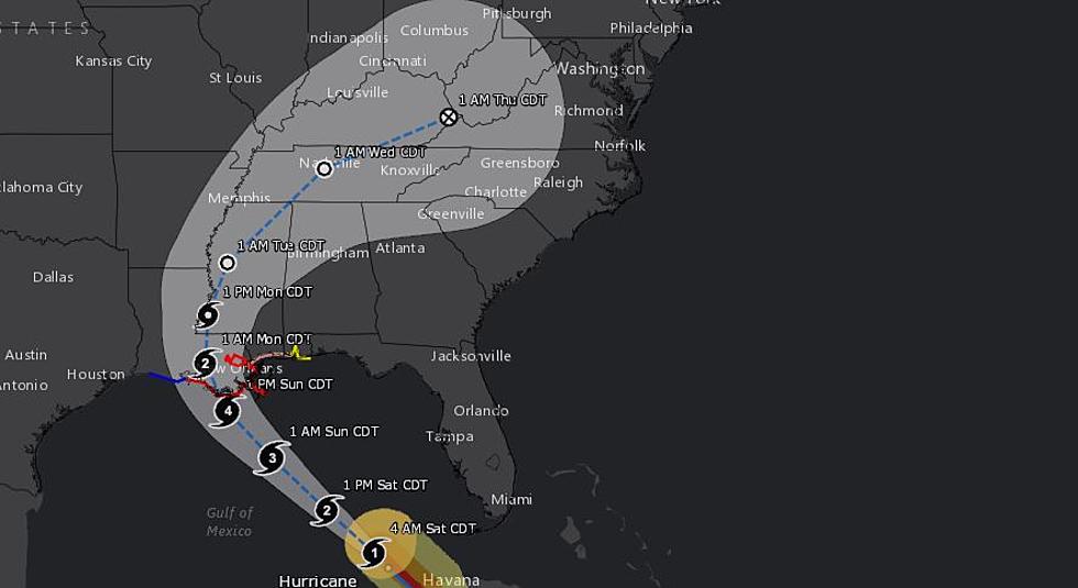
Hurricane Ida is projected to gain strength as it will be over the warm waters of the Gulf of Mexico. If Ida reaches this dangerous strength, this means winds would be between 130-156 miles per hour. This intensification could allow Ida to develop into a Category 4 Hurricane.

This morning Ida was moving at 16 miles per hour and to the northwest with maximum sustained winds of 80 miles per hour. Current tracking places Ida making landfall along the Louisiana coast on Sunday Night.
According to the National Weather Service in Birmingham, “models are coming into very good agreement on the track of Ida and also into better agreement on the timing as Ida slows after landfall moving northward across the Lower Mississippi Valley on Monday, before recurving northeastward towards the Tennessee Valley by Tuesday night. An expansive low and mid-level wind field east of the center will result in impacts for much of Central Alabama.”
West and Central Alabama Impacts
James Spann, ABC 33/40, and Townsquare Media Tuscaloosa Chief Meteorologist has given us more insight on Ida and inland impacts.
Heavy Rain Outlook
“Heavy rain will spread northward across inland parts of Louisiana, Mississippi, and parts of Alabama Monday and Tuesday. For Alabama, the heaviest rain will fall over the western half of the state, where totals of 2-5 inches are likely. Some flooding issues are possible, especially along and west of U.S. 43. East Alabama can expect amounts of 1-2 inches.
Potential Tornado Outlook
A few isolated, brief tornadoes are possible over the western half of Alabama Monday, and then across most of Alabama Tuesday.”
Winds Outlook
“Winds could gust to 35/40 mph across West Alabama Monday, Monday night, and Tuesday morning as Ida weakens, and the core moves northward through Mississippi.”
Current Watches and Warnings from the National Hurricane Center
A Storm Surge Warning is in effect for...
* East of Rockefeller Wildlife Refuge Louisiana to the Mississippi/Alabama state line
* Vermilion Bay, Lake Borgne, Lake Pontchartrain, and Lake Maurepas
A Hurricane Warning is in effect for...
* Intracoastal City Louisiana to the Mouth of the Pearl River
* Lake Pontchartrain, Lake Maurepas, and Metropolitan New Orleans
A Storm Surge Watch is in effect for...
* Sabine Pass to Rockefeller Wildlife Refuge Louisiana
* Mobile Bay
A Hurricane Watch is in effect for...
* Cameron Louisiana to west of Intracoastal City Louisiana
* Mouth of the Pearl River to the Mississippi/Alabama state liner
A Tropical Storm Warning is in effect for...
* Cameron Louisiana to west of Intracoastal City Louisiana
* Mouth of the Pearl River to the Mississippi/Alabama state line
A Tropical Storm Watch is in effect for...
* Mississippi/Alabama state line to the Alabama/Florida state line
(Source) Click here to follow the Facebook Page for James Spann. For more from the National Weather Service Birmingham, click here. Click here for more from the National Hurricane Center.
Ways to Receive Severe Weather Information
Severe Weather Terminology You Should Know
TIPS: Here's how you can prepare for power outages
KEEP READING: Get answers to 51 of the most frequently asked weather questions...
More From Tuscaloosa Thread