More Potential Severe Weather is on the Way for Central Alabama
The Yellowhammer State has gotten through round one of severe weather. We have now turned our attention to monitoring the potential for severe weather over the next few days, especially for this Saturday into Sunday morning. As always, please be sure to check weather conditions as they can change over time.
Thursday Outlook
As heavy rains should continue today, there is a major concern for today is flooding. Currently, the National Weather Service Birmingham has issued a Flash Flood Watch until 6 pm for the following counties: Portions of Central Alabama, including the following counties, Autauga, Bibb, Blount, Calhoun, Chambers, Cherokee, Chilton, Clay, Cleburne, Coosa, Elmore, Etowah, Greene, Hale, Jefferson, Perry, Pickens, Randolph, Shelby, St. Clair, Sumter, Talladega, Tallapoosa, and Tuscaloosa.
Details About Friday
The northern quarter of the station should be aware that there is the possibility of strong and gusty winds. The Storm Prediction Center has a marginal risk for this area. At this moment there is no tornado threat.
Be Prepared for Saturday
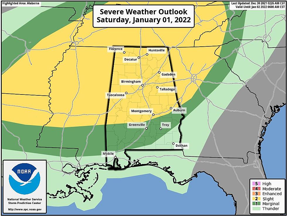
According to James Spann, ABC 33/40, and Townsquare Media Tuscaloosa Chief Meteorologist “there is a "slight risk" (level 1/5) across Alabama as far south as Thomasville, Pike Road, and Opelika, with a "marginal risk" (level 1/5) down to Prichard, Andalusia, and Eufaula. Storms Saturday afternoon and Saturday night could be severe across the state, with the potential for strong winds and hail. There is a conditional tornado threat as well... there is model disagreement about wind fields; we will have better clarity tomorrow. The main window for severe storms, for now, looks to be from about 3:00 Saturday afternoon through 3:00 a.m. Sunday.”
Sunday Specifics
After we get past the severe weather threat, it will feel like winter in the Deep South. Spann said that “much colder air rolls into the state with temperatures falling through the 40s, possibly reaching the 30s by late afternoon. Light rain is likely Sunday morning, and a few snow flurries are possible late in the day and Sunday night. No impact is expected with the snow flurries where they develop.”
(Source) Click here to follow the Facebook Page for James Spann. For more from the National Weather Service Birmingham, click here.
2021 in Review: Top Stories from The Tuscaloosa Thread
All Homicides in Tuscaloosa County in 2021
Most Shocking Crime Stories of 2021
LOOK: What major laws were passed the year you were born?
LOOK: See the iconic cars that debuted the year you were born
LOOK: Things from the year you were born that don't exist anymore
More From Tuscaloosa Thread


