Stay Aware: Details on Upgraded Risk Areas and Threats in Alabama
The Townsquare Media Weather Center has been tracking the possibility of severe weather. We are closely watching an active weather system that could impact many states, including Alabama.
The Weather Channel said, "April is kicking off with a potential severe weather outbreak in the Plains, Midwest, and South.”

Updated Risk Areas
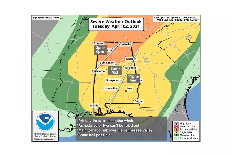
The National Weather Service in Birmingham has updated the risk areas. The "Enhanced Risk" zone has been expanded to include more northern counties, while the "Slight Risk" region has grown to encompass the entirety of Central Alabama, extending southward and eastward.
Possible Threats
The potential threats have also increased with the threat of damaging winds up to 60-70 mph, hail up to ping-pong ball size, and a few tornadoes.
James Spann, ABC 33/40, and Townsquare Media Tuscaloosa Chief Meteorologist said the “highest threat of tornadoes with the system will be north of Alabama, especially across Ohio, where most of the state is in a "moderate risk" (level 4/5).”
Focusing on the severe weather threat in Alabama, “an isolated tornado or two can't be ruled out, however, mainly over the Tennessee Valley of far North Alabama,” said Spann.
Timing Outlook
The overall severe weather threat is between Tuesday 3 p.m. in the northwest until 4 a.m. Wednesday in the southeast.
The timeline for the Townsquare Media Coverage Area is between Tuesday from 3 p.m. until Midnight.
We are closely monitoring this situation and will provide the latest information on Tuesday morning.
Mary K. – Weather Forecaster
2024 Farmers’ Almanac Spring Weather Forecast
Gallery Credit: Mary K
Reasons Why Alabama’s Spring Season Is Unpredictable
Gallery Credit: Mary K
NWS 2024 Severe Weather Preparedness Guide
Gallery Credit: Mary K
Severe Weather Terminology You Should Know
Ways to Receive Severe Weather Information
More From Tuscaloosa Thread


