Increased Concern for Possible Tornadoes, Damaging Winds, & Hail in Alabama
The weather outlook across the United States at the start of April is quite interesting. A snowstorm is impacting the Northern Plains, Great Lakes, and portions of the Northeast, while the Midwest and Southern regions are now preparing for a possible “severe weather outbreak that continues Tuesday from the Ohio Valley into the South,” said The Weather Channel.
Expanded Risk Areas
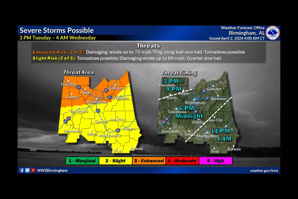
The latest information from the National Weather Service in Birmingham is that the Enhanced Risk and Slight Risk areas have been expanded further.
James Spann, ABC 33/40, and Townsquare Media Tuscaloosa Chief Meteorologist said, “A dynamic weather system will bring showers and thunderstorms into Alabama later today and tonight. SPC maintains an "enhanced risk" (level 3/5) of severe thunderstorms for about the northern third of the state (from Birmingham north), with a "slight risk" (level 2/5) down to the Gulf Coast.”
Townsquare Media Coverage Risk Areas
Bibb - Slight Risk
Fayette - Enhanced Risk
Greene - Slight Risk
Hale - Slight Risk
Lamar - Enhanced Risk
Perry - Slight Risk
Pickens - split between - Enhanced Risk & Slight Risk
Sumter - Slight Risk
Tuscaloosa – split between - Enhanced Risk & Slight Risk
Walker - Enhanced Risk
Timeline
The overall timing for the entire severe weather threat is from 3 pm Tuesday through 4 am Wednesday. However, our immediate Townsquare Media coverage area timing and risk levels vary from county to county.
Townsquare Media Coverage Area Time Zones
Bibb – 6 p.m. until Midnight
Fayette – 3 p.m. until 9 p.m.
Greene – 6 p.m. until Midnight
Hale – 6 p.m. until Midnight
Lamar - – 3 p.m. until 9 p.m.
Perry – 6 p.m. until Midnight
Pickens – 6 p.m. until Midnight
Sumter – 6 p.m. until Midnight
Tuscaloosa – 6 p.m. until Midnight
Walker – mostly – 3 p.m. until Midnight
Potential Threats
Damaging winds up to 60-70 mph
Hail up to ping pong ball size
A few tornadoes
“Heavier thunderstorms late this afternoon and tonight will have the potential to produce strong, damaging straight-line winds and large hail. Also, a few tornadoes are possible, especially in the "enhanced risk" area over North Alabama. But, a tornado can't be ruled out in other parts of the state,” said Spann.

The Townsquare Media Weather Center is on standby to bring you any updates and weather coverage. As always, we stress that as weather conditions develop, this could impact this weather outlook. We will publish the necessary updates as well on-air on our Townsquare Media radio stations Praise 93.3, 92.9 WTUG, 95.3 The Bear, METV 97.5, Catfish 100.1, Tide 100.9, ALT 101.7, and 105.1 The Block.
TIPS: Here's how you can prepare for power outages
KEEP READING: What to do after a tornado strikes
NWS 2024 Severe Weather Preparedness Guide
Gallery Credit: Mary K
Severe Weather Terminology You Should Know
Ways to Receive Severe Weather Information
Reasons Why Alabama’s Spring Season Is Unpredictable
Gallery Credit: Mary K
Things To Have Before It Rains
More From Tuscaloosa Thread


